NATIVE SOILS
Native soils are approximately 18 inches to 6 feet below existing soils. Information about native soils is often not considered in GSI design despite being the foundation of performance. To remedy this, the site location and soils sampling and analysis steps walk you through using data to make informed siting decisions. This data is also integrated into the sizing tool, allowing you to explore how native soils impact decisions about GSI type, dimensions, and performance.
Overview of the role of soils in GSI Design Soils Importance
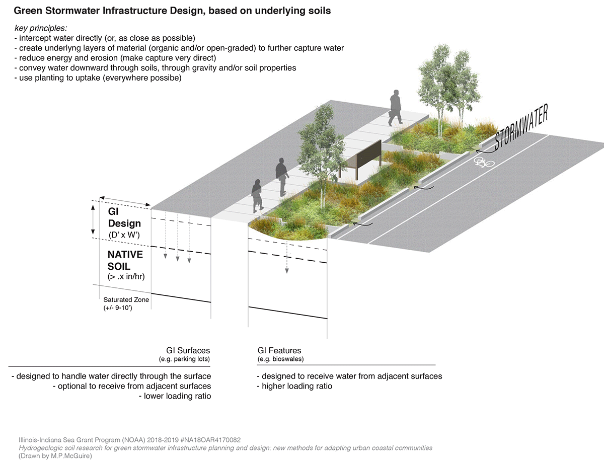
Diagram: Green Stormwater Infrastructure Design, based on underlying soil
This diagram illustrates the role of subsurface native soils in GSI design. The depth (D) of the GSI Design includes existing urban soils original to the site that are often removed and/or modified to create engineered soils. Native soils lie beneath these existing and engineered soils and above the water table (top of the saturated zone).
Soils Variability
Native soils sampling and analysis is important because of soils variability. While soils are often assumed to be uniform, this is not the case; spatial differences in topography, geological history, biota, and other factors cause soils characteristics variation.
Depending on site history, these highly variable soils can differ in texture, structure, and composition within 3 to 5 feet of soils sampling locations. Soils maps provide GSI designers with knowledge of this variability.
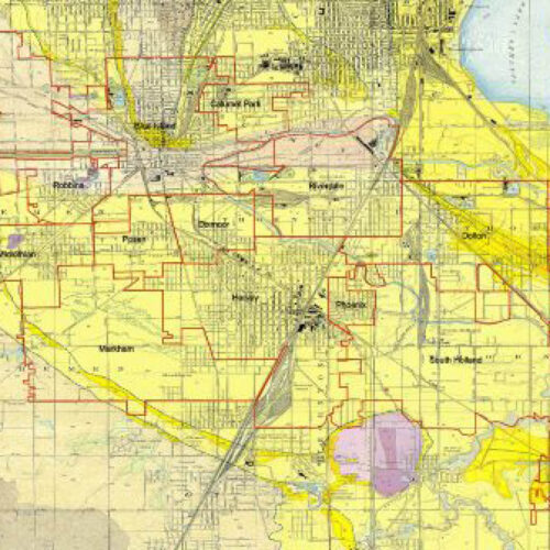
Bretz map illustrating soil variability in the Calumet region
Native Soils Data
Native soils data can be used to help inform green stormwater infrastructure decisions. It is important that regional and local geologic maps be used with topographic, hydrologic, soils, and water table maps to determine the best GSI siting. Users of geologic maps and soil or sediment sample data need some knowledge of past, present, and future geologic, hydrologic, anthropogenic, and soils processes. The collection and analysis of site-specific soils data requires technical expertise for onsite soil fieldwork, description, and measurement.
Useful types of soils data include:
-
- Regional and local surficial geologic maps, such as the Web Soil Survey (WSS), United States Geological Survey (USGS) maps, Hydro Soil Unit Maps: ILWATER interactive web viewer, and recent era Illinois State Geological Survey surficial geology Quadrangle maps. See Resources below.
- Site-specific Soils sampling and Analysis including taking original samples of soils in the GSI site and research (soil analysis), producing descriptive soil boring logs, amoozemeter data (saturated hydrologic conductivity data (Ksat), grain size data (from hydrometer analysis), and water content data.
- Note: This page refers to native “subsoils” occurring at depths ranging from 0.5 to 2 meters (approximately 18 inches to 6 feet below surface) that play a role in water infiltration. For information on existing and engineered soils (the growing media for planted GSI features), and to learn about the different types of soils, see Why are soils important in GSI Design?
Design Process Steps—Incorporating Soils
Investigating native subsoils to inform site location involves collecting existing soils data and samples for analysis. In the siting process, existing soils data is incorporated into site selection. Once site locations are identified, field soil surveys and analysis are recommended. As a result, the team will understand project area soils and be able to refine the green stormwater infrastructure site locations.
Resources
- Web Soils Survey (WSS): provides soil data and information produced by the National Cooperative Soil Survey. It is operated by the USDA Natural Resources Conservation Service (NRCS).
- Illinois Suite of Maps: These maps were produced from data available from the USDA-NRCS.
- Recent era Illinois State Geological Survey surficial geology Quadrangle maps
- Hydro Soil Unit Maps: ILWATER interactive web viewer
- Dustin L. Herrmann, Laura A. Schifman, and William D. Shuster Widespread loss of intermediate soil horizons in urban landscapes, PNAS, June 11, 2018 | 115 (26) 6751-6755 https://doi.org/10.1073/pnas.1800305115
- Gabrielle M. Bethke, Reshmina William, Ashlynn S. Stillwell, Rain Garden Performance as a Function of Native Soil Parameters, Journal of Sustainable Water in the Built Environment, 10.1061/JSWBAY.0000967, 8, 1, (2022). https://experts.illinois.edu/en/publications/rain-garden-performance-as-a-function-of-native-soil-parameters
- Mary Pat McGuire, David A Grimley, Andrew C Phillips, Ashlynn S Stillwell, Reshmina William, Jinyu Shen, Margaret Schneemann, Retrofitting urban land through integrative, subsoils-based planning of green stormwater infrastructure: a research framework, Environmental Research: Infrastructure and Sustainability, 10.1088/2634-4505/ac27bd, 1, 3, (035003), (2021). https://iopscience.iop.org/article/10.1088/2634-4505/ac27bd/meta
- Vaughn, Steven F. et al. “Evaluation of engineered soils for bioretention areas containing dredged Illinois River sand, compost, biosolids, and pyrolyzed biosolids.” Crop, Forage and Turfgrass Management (2021): n. pag. https://acsess.onlinelibrary.wiley.com/doi/pdf/10.1002/cft2.20096